 ET Bureau
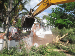
BENGALURU: Even as authorities continued their bulldozing spree bringing down nearly around 100 structures in Doddabommasandra in Bengaluru North it turns out that all is not well with the geographic information system (GIS) projects undertaken by the city municipal corporation to ascertain llegal structures.
Experts believe that superimposing revenue maps from the British era on a GIS platform in order to identify valleys and encroachments is not plausible.
The civic body , which is on a demolition drive, plans to use the results of an ongoing survey along with a 1902 revenue map, to gain better understanding of the storm water drain network and the extent of encroachment as on date. This will be made public soon, municipal commissioner N Manjunath Prasad said.
Noting that such an exercise would be of little use, experts point to other alternatives.
Lok Sabha Elections#Elections With
"The city's area was mapped for the previous comprehensive development plan (CDP), so it's not hard to figure out where the drains are," said Srikanth Nadhamuni, the technology expert behind the country's unique identification authority . "The issue is because we are in a hurry to fix errors done over a period of time." We need a system that factors in events such as flooding etc, before a project is sanctioned, he noted.
BBMP has used GIS to map properties from the point of view of taxation. The project, initiated in 2008, led to improved collection of taxes. However, lakhs of properties remain outside its ambit as the project was not applied systematically . "It's murky . No proper tender procedure was followed," a senior officer said. Its muchawaited GIS-based road history , a platform where every road work would go online, is also hanging, reportedly due to internal resistance.
"Superimposing a British era map on a GIS platform is like correlating history with modernity . Technically, it is prone to errors," GIS expert Mukund K Rao said."I'd suggest laser terrain mapping, which is much more accurate and faster."
Jai Asundi from the Center for Study of Science, Technology and Policy , said flaws in traditional mapping can be overcome through advanced sensing technologies such as Light Detection and Ranging (LiDAR), which generate rich spatial data such as Digital Surface Models. "Delineating drainage boundaries this way is scientific and can be validated," he said.
The demolition drive, which entered its fifth day, has brought down several houses and establishments that allegedly encroached on waterways. Residents, on the other hand, have accused authorities of targeting some and sparing others. By their own admission, authorities are banking on a 114-year-old revenue map to identify "illegal" structures.
Experts believe that superimposing revenue maps from the British era on a GIS platform in order to identify valleys and encroachments is not plausible.
The civic body , which is on a demolition drive, plans to use the results of an ongoing survey along with a 1902 revenue map, to gain better understanding of the storm water drain network and the extent of encroachment as on date. This will be made public soon, municipal commissioner N Manjunath Prasad said.
Noting that such an exercise would be of little use, experts point to other alternatives.
Lok Sabha Elections#Elections With 
- All
- Uttar Pradesh
- Maharashtra
- Tamil Nadu
- West Bengal
- Bihar
- Karnataka
- Andhra Pradesh
- Telangana
- Kerala
- Madhya Pradesh
- Rajasthan
- Delhi
- Other States


"The city's area was mapped for the previous comprehensive development plan (CDP), so it's not hard to figure out where the drains are," said Srikanth Nadhamuni, the technology expert behind the country's unique identification authority . "The issue is because we are in a hurry to fix errors done over a period of time." We need a system that factors in events such as flooding etc, before a project is sanctioned, he noted.
BBMP has used GIS to map properties from the point of view of taxation. The project, initiated in 2008, led to improved collection of taxes. However, lakhs of properties remain outside its ambit as the project was not applied systematically . "It's murky . No proper tender procedure was followed," a senior officer said. Its muchawaited GIS-based road history , a platform where every road work would go online, is also hanging, reportedly due to internal resistance.
"Superimposing a British era map on a GIS platform is like correlating history with modernity . Technically, it is prone to errors," GIS expert Mukund K Rao said."I'd suggest laser terrain mapping, which is much more accurate and faster."
Jai Asundi from the Center for Study of Science, Technology and Policy , said flaws in traditional mapping can be overcome through advanced sensing technologies such as Light Detection and Ranging (LiDAR), which generate rich spatial data such as Digital Surface Models. "Delineating drainage boundaries this way is scientific and can be validated," he said.
The demolition drive, which entered its fifth day, has brought down several houses and establishments that allegedly encroached on waterways. Residents, on the other hand, have accused authorities of targeting some and sparing others. By their own admission, authorities are banking on a 114-year-old revenue map to identify "illegal" structures.
Read More News on
(Catch all the Business News, Breaking News, Budget 2024 News, Budget 2024 Live Coverage, Events and Latest News Updates on The Economic Times.)
...moreDownload The Economic Times News App to get Daily Market Updates & Live Business News.
Subscribe to The Economic Times Prime and read the ET ePaper online.


 Get Unlimited Access to The Economic Times