Gopal Sharma/ Fayaz Bukhari
JAMMU/SRINAGAR, Jan 21: As the western disturbances have hit the entire northern region, the Jammu and Kashmir is witnessing fresh heavy rain and snowfall at many places since this morning, while higher reaches of Pir Panjal and other Himalayan Ranges experienced heavy snowfall, resulting into the danger of avalanche at several places in Kashmir.
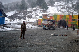
Though Jawahar Tunnel area of Pir Panjal and even Patnitop witnessed fresh snowfall this evening, but the movement of vehicular traffic was going on smoothly till late this evening. But due to slippery road conditions in the Tunnel area the vehicles on one side had been stopped by the Traffic police authorities after 7 pm.
The Director Meteorological department, Sonam Lotus, told the Excelsior that there are reports of light snowfall from Gulmarg, Jawahar Tunnel and other hilly areas of Kashmir valley and plains are witnessing light rain.
Mr Lotus said that there are chances of light snowfall in Valley during the night. “A fresh western disturbance has become active and there are chances of light to heavy and widespread rains and snowfall for three days,” he said.
“There are chances of snow fall during night. There will be light rain till January 23. The weather will remain cloudy till January 25”, the Director said.
Reports said that 6 inch snow had accumulated in Gulmarg, 10 inches in Kangdoori and around one feet in Afferwat. Around 3 inch snowfall was recorded in Furkiyan and Z- Gali and 4 inch on Sadna Top in the frontier district of Kupwara.
In South Kashmir’s Pahalgam and Pirpanjal 3 inches of snowfall was recorded while it was also snowing in Peer-Ki-Gali.
The snowfall and overcast conditions in the Valley and Ladakh region led to increase in the minimum temperature by several degrees bringing some respite from intense cold.
Srinagar recorded a low of 1.7 degrees Celsius, four degrees Celsius above from minus 2.4 degrees Celsius of the previous night.
Pahalgam registered a low of minus 1.4 degrees Celsius, again an increase of four degrees from the previous night’s minus 5.4 degrees Celsius.
Gulmarg recorded the minimum temperature of minus 3.0 degrees Celsius against minus 3.6 degrees Celsius yesterday.
Qazigund recorded a low of minus 0.2 degree Celsius, over three notches up from the previous night’s minus 3.8 degrees Celsius.
Night temperatures in Kupwara, in north Kashmir, settled at a low of 0.5 degree Celsius – an increase of over three degrees from the previous night’s minus 3.1 degrees Celsius.
Kokernag recorded the minimum of 1 degree Celsius, compared to minus 0.9 degrees Celsius yesterday.
In Leh town of Ladakh temperature settled at a minimum of minus 12.4 degrees Celsius, an increase of three degrees from the previous night’s low of minus 15.5 degrees Celsius.
Kargil town registered an increase of about two degrees in the night temperature as the minimum there settled at minus 12.8 degrees Celsius, compared to minus 14.6 degrees Celsius of the previous night.
Meanwhile, a Met official said that entire J&K State and rather Northern States would witness rain while many areas of Kashmir and parts of Jammu region would experience fresh heavy to light snowfall in next two days. Due to western disturbances, the weather has turned inclement in the entire northern region. There would be sharp fall in the temperature and heavy snowfall would occur at many places across the State in coming 48 hours, he maintained.
The day temperature in Jammu has shown significant fall from 18.5 degree C (Yesterday) to 14.2 degree C (today) while the night (min) temperature has shown little increase. During last five days, Jammu witnessed fair and sunny day with a good improvement in Maximum temperature ranging from 18 to 22 degree C. But in coming days, the Jammu’s temperature will further fall.
Katra Mata Vaishnodevi witnessed a minimum temperature of 7.4 degree C, Bhaderwah minimum 3.5 degree C while Banihal town of Ramban district a minimum temperature of 2.0 degree C.
Deputy Commissioner Ramban Farooq Shah Bukhari said that as per communication from Disaster Management Division of Ministry of Home Affairs, some areas of Ramban district are expected to face avalanches during next 48 hours. The people are therefore, advised to take all necessary steps of precautions so that loss of life or property does not happen. All the concerned agencies have also been directed to remain alert.
A senior official from District Administration Poonch said that Mughal Road is totally closed due to heavy snowfall at Pir- ki- Gali and Chhatta Pani area of Pir Panjal. Movement of vehicles ahead at Bufliaz in Surankote is totally stopped. He said that fresh snowfall was also witnessed at Loran and Saujian in Mandi area besides other Dera Gali between Bufliaz and Thannamandi.
Reports of fresh snowfall from Budhal, Gulabgarh, Mahore, Bhaderwah, Doda, Kishtwar, Chhatro, Marwa Dachhan, Dudu-Basantgarh and Bani area have also been received. Trikuta hills of Mata Vaishnodevi shrine have also experienced snowfall. But the movement of pilgrims remained smooth round the clock.
With the improvement in foggy weather conditions, there has been improvement in the timings of the flights and trains in the region. Today all the flights operated normally except first flight which was delayed by half an four and another Spice jet flight which had to be diverted to Amritsar due to bad weather and then left for Delhi at 5.45 pm instead of 3 pm.
A Northern Railways spokesman said that Pooja Express was late by nearly six hours, Jhelum by three and half hours, Lohit nearly two and half hours, Tata Moorie nearly four hours while most of the other trains were little late from their scheduled arrival. He said that with the improvement in foggy weather conditions the train timings have also been improved.