Later this year, humans will be able to watch the Earth breathe with unprecedented clarity.
Carbon dioxide is at the heart of the cycle that sustains life on our planet, and that heartbeat is becoming increasingly irregular. NASA’s new spacecraft will be its heart monitor. But it almost didn’t happen.
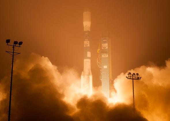
The first iteration of the mission, OCO, crashed into the Indian Ocean near Antarctica shortly after launch in 2009 when part of its protective nose cone failed to separate. The extra weight meant the satellite could never reach orbit.
The mission was deemed so essential that NASA tried again. Last week, NASA successfully launched OCO-2, a nearly exact copy of the original, which promises to revolutionize the study of carbon dioxide on Earth.
Here’s how the satellite will work, from Climate Central:
OCO-2 will be able to peer down through the atmosphere from its perch 438 miles above the planet. It will measure the amount of near-infrared radiation that bounces back from the surface to “see” how much carbon dioxide is in a vertical column of the Earth’s atmosphere at a higher resolution than a Japanese satellite currently in orbit, the only other satellite specifically devoted to measuring CO2.
For the astrophysicist leading the mission, it’s been a long road. Ralph Basilio was on the original team, too, which means he’s been devoted to OCO for more than a decade now. “After we lost OCO in 2009, a lot of it was, you know, shock. You worked on it for 5-6 years, and then all of a sudden, it’s gone.”
And what if last week’s launch had suffered the same fate?
“I’m not sure whether I’d have been able to handle that personally.”
A buildup of atmospheric carbon dioxide from the burning of fossil fuels is the main culprit responsible for the steady rise in global temperatures, the increasingly acidic ocean, and a growing rash of extreme weather events. The problem is, scientists still don’t really know in detail which places on Earth generate the most carbon, whether naturally (via forest fires or peat bogs) or artificially (China—the world’s biggest CO2 emitter—has serious data discrepancies, for example), or where exactly it gets taken up.
There’s already carbon dioxide monitoring equipment—the most famous one is on top of Mauna Loa in Hawaii—but precious little data is collected in the Amazon rainforest, or in the vast temperate forests of Canada and Russia, for example. OCO-2 promises to change all that by creating the very first high-resolution global map of the carbon cycle.
This week, I spoke with Basilio, the project manager for the OCO-2 mission.
Can you briefly describe your role?
I’m the spacecraft mission director. Last Wednesday, I gave the go for launch on behalf of the entire project team.
What’s the question you’re trying to answer with OCO-2?
We want to measure atmospheric carbon dioxide with precision, resolution, and coverage so we can have a better understanding of the carbon cycle and climate change. Where does human-produced carbon go after we release it? We want to study those sinks over time. Are they getting saturated? If so, will more CO2 stay in the air, increasing the threat of climate change? We see this mission as the cornerstone for Earth science in the coming years.
The previous version of the spacecraft was lost in 2009. What were you feeling when you watched the launch and found out it was successful?
I had to give the final go for launch on behalf of the project for the original OCO mission, too. It was probably the worst day I’ve ever had. For me, this was kind of like getting back in the saddle, so there was a little bit more added pressure.
When the clock was ticking down the minutes and seconds before the launch, I could definitely feel my heart beat. It was about an hour and a half after launch (after all the initial safety checks passed) before we could stand up and throw our arms in the air.
What’s the next step in your checklist before you can start conducting science?
We’ve completed all of our initial health checks. Now we need to take the observatory from its parking orbit to its operational orbit as part of a suite of other spacecraft that will help us make best use of our data. But we can do a lot of great science where we’re at today. By the end of the summer or early fall, we’ll start collecting data.
The OCO-2 promises to map carbon sources and sinks on a regional scale for the first time. What will that help climate scientists do?
I believe this mission holds a lot of promise for all of us. The data, the facts that we’re here to get we hope will allow people to make better informed decisions. We feel this is one small way to contribute to a better life for everyone living on the planet today and for future generations. We just want to collect data, and we’ll let the policymakers go from there.
Is there an added sense of urgency to the data you’re collecting? Due to the pressing nature of the climate change problem, as well as the five-year delay in the mission?
There was already a sense of urgency when we tried to launch five years ago. Atmospheric carbon dioxide concentrations have increased from 380 ppm to 400 ppm in just the last five years. Something’s happening, and it’s not just part of the natural process. Everything’s interconnected, and our actions are having an impact. We want to be good stewards of Mother Earth, so we can pass along a planet we’re proud of.
Has anything happened in the last five years that made you think: “Actually, it was great that the first one crashed”?
We have had the great benefit of being able to work with our Japanese colleagues who are operating their own greenhouse gas observing satellite. They approached us and said, “We’d be more than happy to share our data with you to improve your algorithm.” Our scientists have been able to help use that data to get an additional data product. They’ve turned one of our error sources into useful data. It’s kind of like getting lemonade out of lemons. That’s allowed us to provide a bigger bang for the buck that we wouldn’t have had if the 2009 launch had been successful.
I know by definition it’s impossible to predict surprises, but what kinds of things do you think might be waiting for you once the data start rolling in?
We know that excess carbon dioxide from human sources doesn’t all remain in the atmosphere. Is it being absorbed by the oceans? The northern boreal forests? The Amazon rain forest? It may not be in any of those areas. It may be somewhere else entirely. The truth is, right now we have very little information. We may have been looking in the wrong places all along.
Watch the successful launch of OCO-2, which took place in the early morning hours of July 2 at Vandenberg Air Force Base in California: